
From the shores of Prince William Sound, through glacially carved Kenai Mountain passes, to Turnagain tidal flats, trails have long connected the peoples of this mountainous region. Now we can enjoy the benefits of these trails through hiking and biking.
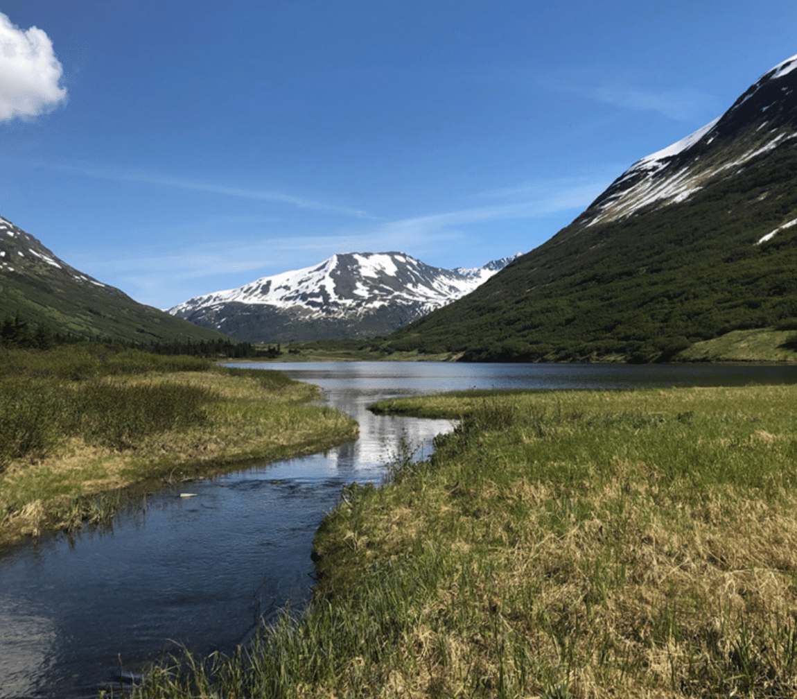
A view from Johnson Pass.
![]()
Start off with a sampling of outstanding trails in KMTA’s
Girdwood area, for both winter and summer hikes.
![]()
![]()

IDITAROD TRAIL, SEWARD
Distance: 1 mile
Terrain: Paved bicycle path
Trail use: Walking and biking
Trailhead: Starts at the Milepost 0 Tripod marker near the Alaska SeaLife Center in downtown Seward. The trail runs north along the shoreline of Resurrection Bay.
A list of KMTA trails would not be complete without including the economic and social lifeline of Alaska’s gold rushes, the Iditarod Trail. The National Historic Iditarod Trail is a 2,300-mile network of trails used for subsistence and trade. The celebrated trail starts in Seward, where travelers today can use a 1-mile paved bike path and visit the Iditarod trailblazer Jujiro Wada memorial.
PRIMROSE & LOST LAKE
Distance: 15 miles
Terrain: Gradual climb of 1,600 feet through spruce forest to open meadows, hemlock, and alpine ridges
Trail use: Hiking, difficult biking; horses allowed after June 30
Trailhead: Primrose: Mile 17 of Seward Highway, travel west 1 mile to Primrose Campground. Lost Lake: Mile 5 of Seward Highway, follow signs up gravel road of Lost Lake subdivision.
This popular trail with buckets of alpine lakes is one of the author’s favorites, whether for backpacking or a big day trip. Consider bringing a fishing rod! Linking Primrose and Lost Lake trail is an elegant point-to-point with a short shuttle ride along the Seward Highway. There are five designated campsites on the trail. Bring your camp stove; no fires allowed above tree line. Snow often lingers in the alpine until mid-July.
RUSSIAN LAKES TRAIL, UPPER & LOWER
Distance: 21 miles
Terrain: Accessible broad path, gentle climbs over the first 3.5 miles of Lower Trail; narrower multiuse trail overlooking wooded rivers and slopes beyond Barber Cabin
Trail use: Hiking, biking; horses allowed after June 30
Trailhead: Lower (north): Mile 52.6 of Sterling Hwy, turn south into Russian River Campground and continue 1 mile. Upper (east): Mile 48 of Sterling Hwy, travel south on Snug Harbor Road for 9 miles, continue on Cooper Lake Road an additional 3 miles.
Listen to the Russian River and look for adventures big and small. From the Lower Trailhead, Russian River Falls is a destination 2.4 miles in with benches and rocks to scramble. Three Forest Service cabins may be reserved at recreation.gov. Barber Cabin, first one from the Lower Russian Lake Trailhead, is 3.5 miles in and wheelchair accessible.
CRESCENT CREEK TRAIL
Distance: 6.3 miles to Crescent Lake, optional bushwhack extension of 8 miles along Crescent Lake Trail connecting with 3.4-mile Carter Lake Trail
Terrain: Rolling and gradual climbs through birch-aspen forest and mountain meadows
Trail use: Hiking, biking; horses allowed after June 30
Trailhead: Mile 45 of Sterling Highway, south onto Quartz Creek Road past the campgrounds to Mile 3.3.
Climb to a long lovely lake and linger. Campsites are located along the wooded shoreline, or reserve the Forest Service cabin. An epic through-hike is possible for those willing and able to tussle with Chugach brush and stream crossings along the southern shore of Crescent Lake to the Carter Lake Trail. This offers a steeper descent to the Seward Highway.
RESURRECTION PASS
Distance: 39 miles
Terrain: Rolling forest floor, gentle switchbacks to assist in the climb from 500 to 2,600 feet
Trail use: Hiking, biking; horses allowed after June 30
Trailhead: South: Mile 53.2 of the Sterling Highway. North: Mile 15 of Hope Highway, turn south onto Resurrection Creek Road for 4 miles on gravel road to the trailhead.
A classic hiking, horse-riding, or biking trail in the summer and ski route in the winter. Eight Forest Service cabins along the route can be reserved and several designated campsites are located amongst spruce forests, lakes, and tundra with seasonal wildflowers and berries. The nearby town of Hope was the first established during the Turnagain Arm gold rush.
GULL ROCK TRAIL
Distance: 5.7 miles
Terrain: Flat, forested, numerous boardwalks, last miles include short steep sections and narrower tread
Trail use: Hiking, difficult mountain biking; horses allowed after June 30
Trailhead: Mile 17.8 of the Hope Highway, turn left on Forest Service signed road to a one-way parking lot ¼ mile from the Highway or access trail from end of the Porcupine Campground.
Of any trail within KMTA, Gull Rock offers a flavor of Turnagain Arm with numerous overlooks and a few social trails to rocky beaches. Avoid walking out to the mudflats because the mud can trap hikers and tidal change can be large and rapid. The parking lot above Hope Highway starts with ~1/2 mile of rolling hilly trail before reaching a toddler-friendly flat section of the Gull Rock Trail. This lot is the trailhead for the steeper Hope Point Trail as well. Campground access leads directly to the gentler trail. The final miles include ascents to a couple of small alpine slopes and tantalizing views of the rocky outcrop at the end of the trail. Backcountry campsites are available at the trail’s end. Gull Rock Trail will see early-season improvements thanks to a USFS-led Alaska Trail Stewards volunteer work party this June.
JOHNSON PASS TRAIL
Distance: 23 miles
Terrain: Forested climb to subalpine meadows
Trail use: Hiking, biking; horses allowed after June 30
Trailhead: North: Mile 64 of the Seward Highway, South: Mile 32.5 of the Seward Highway.
A popular, varied trail for day, overnight, and biking trips, this trail is also known for the need for careful trip timing, especially by bike. Too early, and the trail is still too muddy to sustainably travel on. Too late, and vegetation obscures the trail and sight line. Spruce and hemlock open to wildflower meadows over a gradual 1,000-foot ascent. Travelers can pause at waterfalls and Johnson Lake and overnight at Forest Service designated campsites. The north trailhead is connected to Granite Creek campground and the Hope Highway junction via a paved bike trail along the Seward Highway. Alaska Trail Stewards also plans a summer work party to brush out this trail.
BYRON GLACIER
Distance: 1.4 miles
Terrain: Flat, gravel then rocky with some standing water
Trail use: Hiking
Trailhead: Follow Portage Glacier Road to the Begich Boggs Visitor Center and turn right/south on the Portage Lake Loop. Stay right on Bryon Glacier Road, and watch for signs to the trailhead.
Bring your friends and family to meet a glacier close-up in a way that allows for exploration of ferns, creeks, and snowfields along the way. Byron Glacier is easily visible from the end of the trail. Beyond, boulders deposited by the glacier at its terminus can be a challenge if you choose to negotiate them. Climbing on the glacier is dangerous and should only be undertaken with appropriate training and equipment.
WILLIWAW NATURE TRAIL
Distance: 1.25 mile loop
Terrain: Well-maintained walking trail with boardwalk over bog
Trail use: Walking, biking
Trailhead: Mile 4 of the Portage Glacier Road at the Williwaw Fish Viewing Platform.
The Williwaw Nature Trail hosts a delightful diversity of habitat, history, and human use. From the fish-viewing platform, pass under the highway bridge and travel along Williwaw Creek. The trail crosses Portage Road before connecting to the Trail of Blue Ice; be careful at the crossing. To complete the loop, follow the signs through the Williwaw Campground from the Trail of Blue Ice. Visitors with smartphones can pull them out to learn a bit more about local residents by playing the Agents of Discovery Mission Site (discoveryagents.net). Download the app before you arrive or at the Begich Boggs Visitor Center.
PALMER CREEK
Distance: 1.5 miles to lakes, optional ridge and peak access beyond
Terrain: Gradual climb to lakes, possible stream crossings
Trail use: Hiking
Trailhead: Mile 15 of Hope Highway, turn south onto Palmer Creek Road, continue 12 miles to end of gravel road, last 5 miles are narrow and rocky.
Worth the drive or the bike in, this secret gem of alpine access gives glimpses of Hope’s past and present. There are both both gold mining remnants and a handful of current claims. Glaciers carved two hanging lakes, from which you may strategize a further ridge ramble.
CROW PASS
Distance: 24 miles to Eagle River trailhead
Terrain: Starts uphill with steep sections and switchbacks, some scree, alpine meadows, riparian, and one major river ford at approximately mile 12
Trail use: Hiking
Trailhead: Mile 2 of Alyeska Highway, turn left on Crow Creek Road, continue 5 miles on this gravel road to bridge and turn right uphill. The last mile of road to the trailhead is narrow.
Transition from temperate rainforest to alpine wildflower slopes in 3 lung-pumping miles that earn you 2,080 vertical feet. Variety is the spice of this historic and picturesque trail, one of the National Historic Iditarod Trail routes over the Chugach Mountains. Mining remnants are found 1.7 miles; at mile 3 is a Forest Service cabin along Crystal Lake; a bit farther along the trail is the summit of Crow Pass with tremendous views including Raven Glacier. This challenging trail is worthwhile as a day-hike to the pass or as a multi-day trip if you continue on to the Eagle River trailhead in Chugach State Park.
BEAVER POND
Distance: 2.5 miles
Terrain: Wooded, rolling trail with short, steep climb from northern access
Trail use: Hiking, biking
Trailhead: North: Mile 2 of Alyeska Highway, turn left on Crow Creek Road (gravel) and travel 1/2 mile, just before California Creek bridge; South: 1/2 mile west of Girdwood on the Bird-to-Gird Pathway, look for sign.
Find some quiet woods or a surprise view of Turnagain Arm just a stone’s throw from downtown Girdwood. This locally cherished connector trail has seen recent improvements stewarded by the Girdwood Trails Committee and weeks of additional work are planned for the summer of 2017.

As you explore old favorites, please keep in mind that other users you meet
might be there for the first time. Demonstrate trail etiquette: treat others with
courtesy; let slower users know when you are approaching; yield to horses and
pedestrians. Be a sustainable friend to the trails; travel elsewhere if they are so
muddy that you would leave ruts.