When I was 14 years old—long before I understood the concept of pacing myself—my father decided to take our family on a hike up from the heart of Cooper Landing into the valley holding the headwaters of Slaughter Creek. Dad strapped my four-year-old brother into a backpack and grunted his way along the difficult, rocky ascent, while my mother and younger sister tottered along behind him.
I was reaching the age at which I was losing enthusiasm for “family time” and desired more to be in the company of friends. In a tacit acknowledgement of this adolescent switch, my parents had allowed me to bring along my buddy Monte, a junior high classmate. Together, we were irrepressible in our energy and enthusiasm, racing up the trail ahead of everyone else, chattering like monkeys.
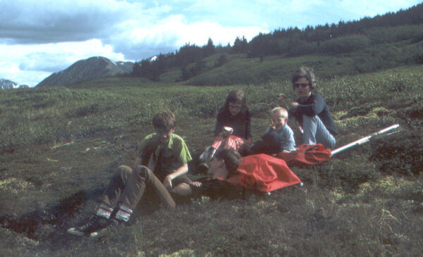
Eventually, all of us reached the saddle—a nexus for decision, where one can choose to rest before descending to the car, drop into the boggy Slaughter Creek drainage for further exploration, climb an adjoining ridgeline to the west, or embark on numerous bushwhacking options. There, my father stepped apart from the rest of us and took a somewhat fuzzy color photograph of the family reclining in the soft moss, proof that all of us on this July 1972 adventure reached the same goal.
In the photo, I am wearing saggy, white cotton athletic socks, black canvas Converse All-Stars, brown jeans and a button-up black bowling shirt given to me by a neighbor. I am chatting with Monte while my mother and sister eat snacks and my brother flashes a peace sign at the camera. On the ground behind me are two red backpacks and a fly-rod case. (Dad wanted to fish for golden-fin trout in the lake at the headwaters of the creek.) In the background, beyond the scrub birch and willow and a scattering of hemlock, Round Mountain protrudes beneath a sky of mixed clouds and patches of blue. The ground around us appears undisturbed, indicative of how few people had ventured to this place.
After the respite—and a brief round of angling—Monte and I attempted to run back down the trail to the car. Neither of us had ever heard of lactic acid or what it could do when it builds up in muscle tissue that has been pummeled by over-exertion. In our exuberance, we also nearly trampled a porcupine waddling blissfully in the trail. Back at the trailhead, well ahead of the rest of the family, we waited impatiently while mosquitoes swarmed and our quads pulsed. Our thighs and knees were so tight by the end of the ride home to Soldotna that we could barely exit the car.
Despite the literal and figurative ups and downs of this experience, the Slaughter Gulch trail—to this day not an official U.S. Forest Service path—became one of my go-to, springtime-warmup treks every year of my early adulthood. The trail’s southern exposure prompts early snow melt, providing clear (albeit sometimes muddy) travel on the lower stretches and quick access to the still-snowy high country.
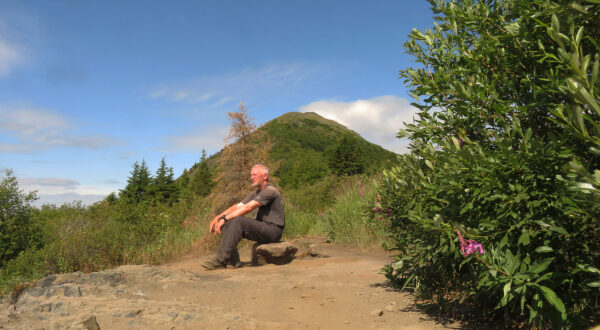
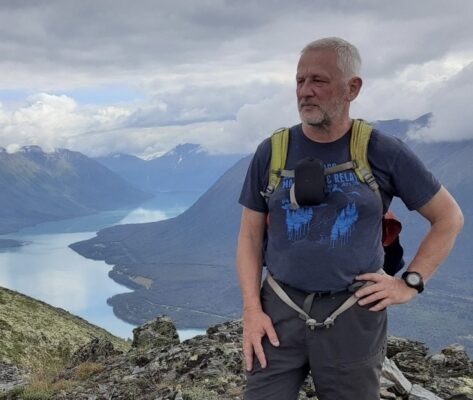
Last summer’s solo trek to the saddle marked the fiftieth year since my first trip up there. At the saddle, I placed my camera on a rock, set the self-timer and posed for a photo near the same place I had rested with my family a half-century earlier. In the image, I am wearing a brown T-shirt and dark gray hiking pants. Wide-box Altras adorn my feet, and a GPS watch encircles my left wrist. I am sweaty, tired, not recently shaved. My hair is short and white. I am 64 years old. Around me, the trail is awash with dust and worn rocks, the result of the passage of thousands of feet. This trail is no longer the alpine oasis of my youth.
Until about 1990, most people I encountered had either never heard of Slaughter Gulch or had heard of it but had no idea where the trail was. I am partly responsible (or to blame) for changing that. Thirty or 40 years ago, when people asked me for directions, I had to carefully explain that a trailhead of sorts lay at the site of an old garbage dump at the end of a short, unmarked road. I had to tell them it was necessary to follow a section line along an unnamed creek tumbling off the mountainside, and that at a small swamp they would have to cross through the muck to the other side and continue upwards and not veer right or left, regardless how tempting it seemed to do so. Beyond the swamp, I’d tell them, the trail wasn’t well developed but was easy to follow.
My tendency back then was to share the trail. After all, it didn’t belong to me. It was public land. (Still is.) That’s also one of the reasons I began taking friends along, to show them the route. Twice, I led full cross-country teams up the adjoining ridge to the summit, reached by climbing around or through the hemlock grove at the saddle. On a hike there in 2003, however, I sensed that I may have created a problem: Three friends and I encountered 26 other people (and their dogs) on the mountain that day.
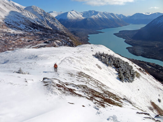
In 2020, a year after the Swan Lake Fire had incinerated the Skyline Trail, I was told by friends planning to hike into Slaughter Gulch that they had had to park out near the highway and walk past a line of more than 25 vehicles just to reach the trailhead. I now see photos of Kenai Lake from atop the Slaughter Gulch saddle or summit appear regularly in Facebook postings. The formerly hard-to-find trail has become obvious, clearly delineated by a swath of dirt and worn stone from bottom to top. Now, even in winter when I’m snowshoeing to the summit, I rarely see fewer than a half-dozen other travelers, slogging similarly along.
In fact, today’s Slaughter Gulch trail bears little resemblance to the one I first climbed 51 years ago. The old section line now edges along a row of houses. The lower trail crosses the scar on which the Sterling Highway bypass road is being constructed. (In fact, it seems likely that it will eventually be unnecessary to hike the lowest part of the trail at all anymore, as most people will begin their trek from the bypass.) Much of the comfy moss at the saddle has either been filled in by the rising tide of willow and alder or has become rutted and plant-free by the pounding of human traffic. Someone ran a chainsaw through the hemlocks years ago and opened up a passage to the ridge. And the path from there to the summit has become a groove, braided like a stream in the wider spots. At the summit these days is a rock cairn and a geocache.
But don’t assume that I write all of this as a lament. Not at all.
Sometimes, to be sure, I wish I still had the mountain more to myself. But, despite having to share the space with so many fellow hikers, I continue to climb that trail. It still offers splendid views and the comfort of familiarity. It is still one of my favorite places on the planet.
-Clark Fair
 Clark Fair, a former journalist and high school English teacher, is a lifelong Alaskan who has lived for more than 60 years on the Kenai Peninsula, starting on a family homestead between Soldotna and Sterling. Since retiring from teaching, he has been a freelance writer, researcher and photographer. An avid hiker, Clark has explored many of the mountains and valleys of the Kenai Peninsula, and he derives special joy from discovering ties to tales from the peninsula’s colorful past.